Before I begin I think its important to define two meteorology terms. Those terms are squall line and a Derecho. A squall line is a line of severe thunderstorms that produces straight line winds over 60 mph and often has tornadoes embedded in the line. A derecho is a type of squall line that moves fast, the thunderstorms in a derecho produce winds over 75 mph, and often tornadoes are embedded in a derecho.
On July 14th my area was hit hard by a Derecho event. I decided I would make a thread about this event since it was exactly 10 years ago.
I can remember on July 11th on my weather page talking about how on the 14th we could have a Derecho event almost all the models were showing a Derecho developing the ingredients were coming together. There was a frontal boundary stretching from Missouri and Illinois all the way down to the upper part of South Carolina. A storm system was coming out of the Rockies and behind this storm system was a 100 mph jet in the mid-levels. The jet was also creating wind energy as the same models were showing 90 mph winds in the mid levels. Then you had hot temperatures providing thermal energy.
On July 12th the storm system caused severe weather to break out in Wyoming, Colorado, Nebraska, and Kansas. On the 13th severe weather broke out in South Dakota, Iowa, Nebraska, and Missouri. Also on the 13th I started to talk about how the next day was going to be bad for my area. I stressed that these types of storms would do tornado like damage.
On the morning of July 14th a cluster of storms developed in Missouri and later Illinois. As the day progressed the cluster of storms turned into a squall line and began to move southeast along the frontal boundary. When the storms got into Kentucky they really intensified due to daytime heating. The storms started to produce 75 mph winds and tornadoes. The line was also getting stronger. The Storm Prediction Center placed Central/East Kentucky, Central/East Tennessee, and North Alabama and North Georgia under severe thunderstorm watches.
Later that afternoon the line had turned into a Derecho the storms really strengthened when they entered Tennessee they were now producing not just tornadoes but 80-90 mph straight line winds. In the early evening the Derecho moved into east Tennessee. Things got really hectic for me because I started to post warnings on my weather page as they were issued. I was also having to keep an eye on the sky for myself.
The line got into my area and produced damaging straight line winds 80-90 mph. There was wide spread wind damage. The Derecho also spawned a tornado. As the evening went on the line made its way into Alabama and Georgia producing similar results. Finally, the line made it into upper South Carolina.
This Derecho was moving 60-65 mph due to the strong winds pushing it southeast. The 90-100 mph winds at the mid-levels allowed the thunderstorms to tap into the winds and produce them at the surface. Kentucky, Tennessee, Alabama, and Georgia were hit hard by this event.
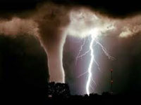
As I stated in my area there was wide spread wind damage. Large trees were uprooted, power lines were snapped in half, several homes had damage via roof damage or siding. Several mobile homes were destroyed. A few amusement parks also sustained severe damage due to the power of the storms. A tornado was confirmed in Monroe County TN with winds 100 mph making it an EF1 tornado. This tornado destroyed several barns and did severe damage to a few houses.
However, this line also caused flash flooding. The thunderstorms in the Dercho produced rainfall rates of 0.75-1.25 per hour leading to flash flooding. The utilities had to shut off power lines that were in the water so nobody would get electrocuted.
Overall, this event spawned 3 tornadoes in Kentucky, 3 in Tennessee (including the one near my area), and 5 in Alabama. This event also caused millions of dollars in damage across the states of Kentucky, Tennessee, Alabama, Georgia, and South Carolina.
The wind from this event was crazy. I measured a wind guest up to 61 mph but other places in my county measured winds over 80 mph. The power flickered on and off before finally going out. I actually had to get into my shelter because the wind was so bad. Also due to the heavy rain I did not know if there was a tornado hidden in the rain or not. As a meteorologist I still reference this event when I talk about straight line winds. I often remind my viewers that straight line winds can be just as bad as a tornado and this event along with others proved that.
Before I begin I think its important to define two meteorology terms. Those terms are squall line and a Derecho. A squall line is a line of severe thunderstorms that produces straight line winds over 60 mph and often has tornadoes embedded in the line. A derecho is a type of squall line that moves fast, the thunderstorms in a derecho produce winds over 75 mph, and often tornadoes are embedded in a derecho.
On July 14th my area was hit hard by a Derecho event. I decided I would make a thread about this event since it was exactly 10 years ago.
I can remember on July 11th on my weather page talking about how on the 14th we could have a Derecho event almost all the models were showing a Derecho developing the ingredients were coming together. There was a frontal boundary stretching from Missouri and Illinois all the way down to the upper part of South Carolina. A storm system was coming out of the Rockies and behind this storm system was a 100 mph jet in the mid-levels. The jet was also creating wind energy as the same models were showing 90 mph winds in the mid levels. Then you had hot temperatures providing thermal energy.
On July 12th the storm system caused severe weather to break out in Wyoming, Colorado, Nebraska, and Kansas. On the 13th severe weather broke out in South Dakota, Iowa, Nebraska, and Missouri. Also on the 13th I started to talk about how the next day was going to be bad for my area. I stressed that these types of storms would do tornado like damage.
On the morning of July 14th a cluster of storms developed in Missouri and later Illinois. As the day progressed the cluster of storms turned into a squall line and began to move southeast along the frontal boundary. When the storms got into Kentucky they really intensified due to daytime heating. The storms started to produce 75 mph winds and tornadoes. The line was also getting stronger. The Storm Prediction Center placed Central/East Kentucky, Central/East Tennessee, and North Alabama and North Georgia under severe thunderstorm watches.
Later that afternoon the line had turned into a Derecho the storms really strengthened when they entered Tennessee they were now producing not just tornadoes but 80-90 mph straight line winds. In the early evening the Derecho moved into east Tennessee. Things got really hectic for me because I started to post warnings on my weather page as they were issued. I was also having to keep an eye on the sky for myself.
The line got into my area and produced damaging straight line winds 80-90 mph. There was wide spread wind damage. The Derecho also spawned a tornado. As the evening went on the line made its way into Alabama and Georgia producing similar results. Finally, the line made it into upper South Carolina.
This Derecho was moving 60-65 mph due to the strong winds pushing it southeast. The 90-100 mph winds at the mid-levels allowed the thunderstorms to tap into the winds and produce them at the surface. Kentucky, Tennessee, Alabama, and Georgia were hit hard by this event.
As I stated in my area there was wide spread wind damage. Large trees were uprooted, power lines were snapped in half, several homes had damage via roof damage or siding. Several mobile homes were destroyed. A few amusement parks also sustained severe damage due to the power of the storms. A tornado was confirmed in Monroe County TN with winds 100 mph making it an EF1 tornado. This tornado destroyed several barns and did severe damage to a few houses.
However, this line also caused flash flooding. The thunderstorms in the Dercho produced rainfall rates of 0.75-1.25 per hour leading to flash flooding. The utilities had to shut off power lines that were in the water so nobody would get electrocuted.
Overall, this event spawned 3 tornadoes in Kentucky, 3 in Tennessee (including the one near my area), and 5 in Alabama. This event also caused millions of dollars in damage across the states of Kentucky, Tennessee, Alabama, Georgia, and South Carolina.
The wind from this event was crazy. I measured a wind guest up to 61 mph but other places in my county measured winds over 80 mph. The power flickered on and off before finally going out. I actually had to get into my shelter because the wind was so bad. Also due to the heavy rain I did not know if there was a tornado hidden in the rain or not. As a meteorologist I still reference this event when I talk about straight line winds. I often remind my viewers that straight line winds can be just as bad as a tornado and this event along with others proved that.
--------------------


 User Notice