The year 2020, which was 4 years ago, was a wild year in Meteorology. 2020 would be filled with deadly tornado outbreaks, deadly hurricanes, record breaking heat, and heavy winter storms. In the second half of 2019 conditions in the ENSO region (Equatorial Waters of the Pacific Ocean) were neutral. However, in 2020 La Nina showed signs of rapidly developing. By Spring La Nina conditions had been established. This La Nina would last from March 2020 to early 2023. The changing to La Nina is what caused a lot of wild weather in 2020.
January 2020 got off to a storm start especially in the South, and parts of the Midwest. Around January 8th I started to see a potent storm system developing in Oklahoma and Texas. As a Meteorologist I was really concerned about this storm system. Ahead of the storm system temperatures were mostly in the 70's. Behind this storm system was chilly air. What concerned me the most was the 90 mph winds in the mid-levels of the atmosphere and the amount of wind shear was seeing. I started talking on my weather page how this was a system we would need to watch. I saw the potential for a Derecho event along with tornadoes.
A squall line is a line of severe storms that has damaging winds over 58 mph and often tornadoes embedded in the line. A Derecho is a fast moving squall line that covers over 250 miles in a short amount of time. The thunderstorms in a Derecho can produced winds over 75 mph as well as tornadoes.
January 9th, I made a forecast that my area and others could be hit with severe storms. I stated we could be facing a long lived line of thunderstorms with damaging winds and tornado potential.
Early January 10th I saw 90-95 mph winds in the mid-levels of the atmosphere, wind shear, a surge of moisture coming from the Gulf, and warm air colliding with chilly air. All the ingredients were coming together for a severe weather outbreak.
Late January 10th severe storms started to develop in Oklahoma and Texas. The storms quickly organized into a squall line. The strong winds kept the squall line growing.on January 11th the Squall line started in Central Missouri and went all the way down to the Gulf Coast. This line started to move east at a rapid pace.
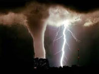
In fact, as the lined moved eastward it strengthened. The thunderstorms started to produce straight line winds of 75-90 mph and several tornadoes touched down. My area was placed under severe weather watches. I quickly posted how it was crunch time. As warnings started to be issued I quickly posted them.
My area was hit hard by this Derecho. My area had tornadoes and several reports of wind damage. Some of the storms in my area were estimated to have winds up to 80 mph. However, other states and areas were hit hard.
The states and areas of Louisiana, Mississippi, Alabama, Georgia, Tennessee, Kentucky, South Carolina, Southern Illinois, Southern Indiana, and Southern Ohio were hit hard with damaging straight line winds and tornadoes.
By nightfall the Derecho had made it all the way to Greenville South Carolina. It was amazing how in less than 24 hours the line went from Central Missouri to Upstate South Carolina.
The Derecho and tornado outbreak produced 80 confirmed tornadoes, hundreds reports of straight line wind damage. 7 people perished and $1.2 Billion dollars of damage was done.
Looking back on it now this event was the catalyst for a series of severe weather outbreaks that plagued the same area all the way till June. A few weeks later another event would rock the same area. March was also destructive. The most destructive outbreak occurred in Easter in the same area.
What made this event historic was the timing of the event. Getting a Drecho event like this is not unheard of. But, most Derecho's occur in the spring and summer. Sometimes the South can get them in the late fall. It is rare to get an event like this in January. Usually severe weather is limited to inner California or the Gulf Coast for January. But with warm temps in the 70's, lots of moisture and strong wind energy it all came together to produce an early severe weather outbreak.
The year 2020, which was 4 years ago, was a wild year in Meteorology. 2020 would be filled with deadly tornado outbreaks, deadly hurricanes, record breaking heat, and heavy winter storms. In the second half of 2019 conditions in the ENSO region (Equatorial Waters of the Pacific Ocean) were neutral. However, in 2020 La Nina showed signs of rapidly developing. By Spring La Nina conditions had been established. This La Nina would last from March 2020 to early 2023. The changing to La Nina is what caused a lot of wild weather in 2020.
January 2020 got off to a storm start especially in the South, and parts of the Midwest. Around January 8th I started to see a potent storm system developing in Oklahoma and Texas. As a Meteorologist I was really concerned about this storm system. Ahead of the storm system temperatures were mostly in the 70's. Behind this storm system was chilly air. What concerned me the most was the 90 mph winds in the mid-levels of the atmosphere and the amount of wind shear was seeing. I started talking on my weather page how this was a system we would need to watch. I saw the potential for a Derecho event along with tornadoes.
A squall line is a line of severe storms that has damaging winds over 58 mph and often tornadoes embedded in the line. A Derecho is a fast moving squall line that covers over 250 miles in a short amount of time. The thunderstorms in a Derecho can produced winds over 75 mph as well as tornadoes.
January 9th, I made a forecast that my area and others could be hit with severe storms. I stated we could be facing a long lived line of thunderstorms with damaging winds and tornado potential.
Early January 10th I saw 90-95 mph winds in the mid-levels of the atmosphere, wind shear, a surge of moisture coming from the Gulf, and warm air colliding with chilly air. All the ingredients were coming together for a severe weather outbreak.
Late January 10th severe storms started to develop in Oklahoma and Texas. The storms quickly organized into a squall line. The strong winds kept the squall line growing.on January 11th the Squall line started in Central Missouri and went all the way down to the Gulf Coast. This line started to move east at a rapid pace.
In fact, as the lined moved eastward it strengthened. The thunderstorms started to produce straight line winds of 75-90 mph and several tornadoes touched down. My area was placed under severe weather watches. I quickly posted how it was crunch time. As warnings started to be issued I quickly posted them.
My area was hit hard by this Derecho. My area had tornadoes and several reports of wind damage. Some of the storms in my area were estimated to have winds up to 80 mph. However, other states and areas were hit hard.
The states and areas of Louisiana, Mississippi, Alabama, Georgia, Tennessee, Kentucky, South Carolina, Southern Illinois, Southern Indiana, and Southern Ohio were hit hard with damaging straight line winds and tornadoes.
By nightfall the Derecho had made it all the way to Greenville South Carolina. It was amazing how in less than 24 hours the line went from Central Missouri to Upstate South Carolina.
The Derecho and tornado outbreak produced 80 confirmed tornadoes, hundreds reports of straight line wind damage. 7 people perished and $1.2 Billion dollars of damage was done.
Looking back on it now this event was the catalyst for a series of severe weather outbreaks that plagued the same area all the way till June. A few weeks later another event would rock the same area. March was also destructive. The most destructive outbreak occurred in Easter in the same area.
What made this event historic was the timing of the event. Getting a Drecho event like this is not unheard of. But, most Derecho's occur in the spring and summer. Sometimes the South can get them in the late fall. It is rare to get an event like this in January. Usually severe weather is limited to inner California or the Gulf Coast for January. But with warm temps in the 70's, lots of moisture and strong wind energy it all came together to produce an early severe weather outbreak.


 User Notice